Glaciers

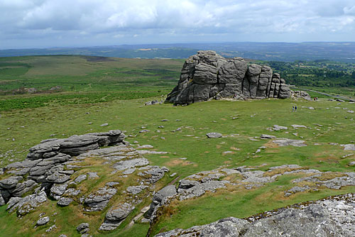
The UKs landscape was shaped during the ice ages but in mountainous and high latitudes, glaciers are still carving their way across the land.

Here are some facts about glaciers from National Geographic Kids that I thought would be useful to know:

  1. Glaciers are huge masses of ice that ‘flow’ like very slow rivers. They form over hundreds of years where fallen snow compresses and turns into ice.
  2.  Glaciers form the largest reservoir of fresh water on the planet. In fact, they store 75% of the world’s fresh water!
  3. Today, glaciers cover around 10% of the Earth’s total land area. During the last ice age they covered 32%. Brrrr!
  4. Glaciers are usually divided into two groups – Alpine glaciers, which form on mountainsides and move downward through valleys, and Continental ice sheets, which spread out and cover larger areas.
  5. The world’s largest glacier is Lambert Glacier, located in Antarctica, measuring approximately 100km wide, 400km long and 2.5km deep!
  6. Because glacial ice is so dense and compact, it often appears a bright blue!
  7. The Kutiah Glacier in Pakistan has the record for the fastest glacier surge. In 1953, it moved more then 12km in three months.
  8. Earth’s two ice sheets cover most of Greenland and Antarctica and make up more than 99% of the world’s glacial ice.
  9. If the Antarctic ice sheet were to melt entirely, it is estimated that sea levels would rise by around 65m. That means that London would be lost underwater!
  10. Glacial ice can be hundreds of thousands of years old, which makes it a valuable resource for assessing climate change. By extracting and analysing the ice, scientists can learn about what the climate was like on Earth thousands of years ago!

Glaciers are essentially large masses of densely packed ice that has formed over many years when snow and ice builds up faster than it is removed (ablation) through melting and evaporation. A glacier is formed in an area called a corrie. They are usually a bowl shaped area between mountains where snow can collect and build up easily. Corries are also known as cwms or cirques. The snow is compressed and the air is squeezed out to become névé. Glacial ice will continue to fill the névé until eventually a geological weakening or gap between mountains means the ice mass will start to move down a slope surface.

Erosion and weathering by abrasion, plucking and freeze-thaw action will gradually make the corrie bigger. These processes create a characteristic rounded, armchair shaped hollow with a steep back wall.

corrie and tarn

When ice in a corrie melts, a circular lake is often formed at the bottom of the hollow. This is known as a tarn.

How do glaciers shape the landscape?

There are three processes by which glaciation affects the landscape, erosion, transportation and deposition. There is an opportunity for some revision here on different processes.

Freeze-thaw weathering describes the action of glacial meltwater on joints, cracks and hollows in rock. When the temperature reaches freezing point, the water inside cracks freezes, expands and causes the cracks to widen. When the temperature rises, the water thaws and contracts. This eventually causes rocks to break up.

Freeze-thaw weathering produces angular rock fragments.

Plucking occurs when rocks and stones become frozen to the base or sides of the glacier and are plucked from the ground or rock face as the glacier moves. It leaves behind a jagged landscape.

glacial plucking

Abrasion occurs when rocks and stones become embedded in the base and sides of the glacier. These are then rubbed against the bedrock (at the bottom of the glacier) and rock faces (at the sides of the glacier) as the glacier moves. This causes the wearing away of the landscape as the glacier behaves like sandpaper. It leaves behind smooth polished surfaces which may have scratches in them called striations. Striations are carved out by angular debris embedded in the base of the glacier.

glacial striations

The BBC has a great class clip about the Franz Josef Glacier in New Zealand which gives students an visual idea of the scale of glaciers. It does mention some other key terms which I haven’t looked at yet but I will be looking in more detail at the erosional and depositional landforms in my next blog.

http://www.bbc.co.uk/learningzone/clips/the-franz-josef-glacier-formation-and-flow/3079.html

Or there is this other short video which explains some processes but doesn’t give students chance to see the scale of glaciers.

http://www.bbc.co.uk/schools/gcsebitesize/geography/glacial_landscapes/glacial_erosion_landforms_video.shtml

If a glacier flow meets the sea or ocean a block may break off or calve and an iceberg is formed.


Glaciation and Ice Ages

Another area of physical geography that I feel that I need to refresh my knowledge is glaciation.

The AQA Geography A specification suggest starting with students understanding how the amount of ice on land has changed throughout the Earth’s history, starting with the Last Ice Age during the Pleistocene epoch.

The Pleistocene lasted from about 2,588,000 to 11,700 years ago, spanning the world’s recent period of repeated glaciations. The end of the Pleistocene corresponds with the end of the last glacial period. The continents as we know them today were pretty much in position. It might be a good opportunity here to revisit the geological timescales and plotting events to give students a visual guide to how far back the last ice age occurred.

Glacial Features During the Ice Age

The Pleistocene climate was marked by repeated glacial cycles. Glacial periods are separated by “interglacial periods” during which the glacier experiences minor advances and retreats.

It is estimated that, at maximum glacial extent, 30% of the Earth’s surface was covered by ice as well as a zone or permafrost stretching southwards from the edge of the glacial sheet.

During each glacial advance, huge volumes of water were frozen in continental ice sheets resulting in sea level drops of 100m or more but during the interglacial periods coastlines would flood.

Global Effects

Antarctica was icebound throughout the Pleistocene.

North America, Northern Europe, including Great Britain were covered in ice and the northern seas were ice-covered. Ice sheets originated not at the poles, but in the lower continents. The Laurentide ice sheet originated in the Hudson Bay, the Cordilleran ice sheet formed in the Canadian Rockies, the Finoscandinavian ice sheet started in Scandinavia, and the Alpine ice sheet emanated from the Swiss Alps.

Ice sheets already present in Antarctica and Greenland thickened.

There were glaciers in New Zealand, Tasmania, in the east and central Africa in the mountains ranges and the Andes were covered by ice caps.

When the North American ice sheet retreated, north central North America was totally covered by Lake Agassiz. Over a hundred basins, now dry or nearly so, were overflowing in the North American west. Lake Bonneville, for example, stood where Great Salt Lake now does.

In Eurasia, large lakes developed as a result of the runoff from the glaciers. Rivers were larger, had a greater flow, and were braided.

Deserts were drier and more extensive. Rainfall was lower because of the decrease in oceanic and other evaporation.

Pleistocene_north_ice_map

Extent of ice in the Northern Hemisphere

Using a timeline and map work could help students here grasp key concepts of place and scale through plotting the advance and retreat of glaciers and ice sheets.

Why did the Ice Age Happen?

Scientists aren’t sure what causes ice ages, or what combination of events might trigger another one but some of the theories include one or a combination of these factors:

Milankovitch Cycles

In the 1920s, a mathematician named Milutin Milankovitch worked out why summers would be cooler by looking at the factors that limit sunlight’s reach to Earth. He identified three factors: the tilt in the Earth’s axis, the way the Earth wobbles on its axis and how close the Earth gets to the sun. By combining these factors in a mathematical formula, he was able to predict that ice ages would occur every 22,000, 41,000 and 100,000 years. These rhythms became known as Milankovitch cycles.

This is a great short video from the BBCs class clips explaining how this works.

http://www.bbc.co.uk/learningzone/clips/the-current-ice-age/14195.html

Orbital_Laepple

Albedo

Once it’s cold, then it’s likely to stay cold. Ice has albedo, or reflectivity. A higher albedo results in less absorbed sunlight because it’s reflected back. This causes temperatures to drop more, so that the growth of one glacier will likely trigger more glaciers..

Landmasses at high altitudes and latitudes are more likely to be cold and provide the conditions for glaciers to form. The changes caused by plate tectonics also include uplift brought on by plate collision, mountain ranges formed by plates overriding each other and oceanic trenches created by plates moving away from each other. These slow movements change the Earth’s composition and could bring on the climate conducive to an ice age.

albedo

Atmospheric Gases

Studies of trapped air from glacial ages have indicated that carbon dioxide and methane gases were at lower levels. When these greenhouse gases are abundant, they trap energy and keep it close to Earth, thus keeping the planet warm. When these gases aren’t present, that radiant energy escapes..

Studies indicate that there may have been an unusually high amount of dust in the air during the Pleistocene Ice Age, which would have blocked the sun and kept the Earth’s temperature cool for example ash clouds during volcanic eruptions. It appears that there were periods of intense volcanic activity preceded glacial ages.

Sunspot Activity

A sunspot is a cool, dark spot on the sun that contains magnetic energy. Although sunspots are cooler than the rest of the sun, their presence keeps it warmer on the Earth because their resulting magnetic field cuts cloud cover. With lower sunspot activity, cloud cover increases, cutting off the sun’s rays from the Earth

There are clearly a lot of key words and theories that students need to comprehend, creating a glossary may help here. Using classroom display boards around the topic could also help. Students in the school I am in at the moment are using these theories to look at possible explanations of climate change. Using them in different topic areas will give students confidence and revisiting theories will help with revision.

Coasts – Depositional Landforms and Coastal Management

The material that is eroded from coasts are transported by the sea to other locations and deposited to form other coastal features.

The most common coastal feature as the result from deposited material are beaches through constructive waves. The material of a beach varies depending on the geology of the local area. Beach profiles, i.e. the cross section of a beach, vary depending on the material. Sandy beaches tend to have a shallower profile while shingle beaches will be steeper. Also finer material is found nearer the shoreline as the water erodes the material through attrition whereas larger material will usually be found further away from the sea which were deposited there during periods of high energy such as storms.

A spit is an extended stretch of beach material that projects out to sea and is joined to the mainland at one end. Spits are formed where the prevailing wind blows at an angle to the coastline, resulting in longshore drift. As the spit builds out to sea the end is affected more by the wind and by wave currents, causing the end to curve towards the shore, to create a hook end. Material often accumulates in the area of standing water that occurs behind a spit, and this can lead to the formation of salt marshes

spit

A tombolo is a spit connecting an island to the mainland. An example of a tombolo is Chesil Beach, which connects the Isle of Portland to the mainland of the Dorset coast.

Chesil beach

Chesil Beach – example of a tombolo

A bar is a ridge of sand that blocks off a bay or river mouth. It will create a lagoon behind it is across a non-river bay.

bar

Bar


Managing Coastal Erosion and Deposition

When looking at coastal management I feel it is important for our students to understand that there are a number of different demands and uses on the coastal land and it is sometimes a hard decision how to protect coastlines as some management strategies are extremely expensive but sometimes people’s houses and livelihoods are at risk from falling in to the sea, and sometimes we just have to let nature take its course. I think this a great topic to highlight the interconnections between the human and physical world. I think an ideal way to look at this topic is to use fieldwork, something which is encouraged in the National Curriculum. Leicester is not too far from the east coast where students would be able to see a number of coastal features and management strategies. Parts of the Norfolk coastline were also damaged during the storms earlier in the year giving students an opportunity to observe first hand coastal erosion and the effect on people’s lives.

A little bit of revision on sea defences!

Building a sea wallA wall built on the edge of the coastline.Have a life span of about 75 years.sea wall  AdvantagesProtects the base of cliffs, land and buildings against erosion. Can prevent coastal flooding in some areas.DisadvantagesExpensive to build. Curved sea walls reflect the energy of the waves back to the sea. This means that the waves remain powerful. Over time the wall may begin to erode. The cost of maintenance is high. Can cause the beach in front of them to erode.
Building groynesA wooden barrier built at right angles to the beach.They have a life span of 25 years.groynes  AdvantagesPrevents the movement of beach material along the coast by longshore drift.Allows the build up of a beach. Beaches are a natural defence against erosion and an attraction for tourists.DisadvantagesCan be seen as unattractive.

Costly to build and maintain.

Rock armour / Rip rapLarge boulders are piled up on the beach.rip rap AdvantagesAbsorb the energy of waves.Allows the build up of a beach.DisadvantagesCan be expensive to obtain and transport the boulders.

Boulders have to be big enough to withstand being eroded quickly.

GabionCages of stones on a beachThey have a life span of 20 – 25 years. gabion AdvantagesDesigned to absorb wave energyAllows build up of the beachDisadvantagesSteel will rust eventually and rocks erode.
Beach NourishmentReplenishing sand on the beach either from elsewhere or transported back along the beach.beach nourishment AdvantagesBeaches are a natural defence against erosion and coastal flooding. Beaches also attract tourists.Relatively inexpensive.Disadvantages

Requires constant maintenance.

Managed RetreatAreas of the coast are allowed to erode naturally. AdvantagesEncourages natural development of beaches.Cheap optionDisadvantagesUnpopular with landowners

May need to pay compensation.


Problems of disrupting the natural coastal system:

  • Whenever you tamper with nature there are going to be knock on effects, which could, in time, become worse than the original problem.
  • Coastal defence strategies are often very localised, and can cause problems further down the coast. One such example could be seen where groynes are used to trap sediment. Further down the coast there could be a reduction in the amount of material available to protect the coast there. This in turn would mean an increased amount of coastal erosion.


Coastal Landforms and Processes

When researching the different rock landforms I thought that this topic could be linked in with coastal erosion. So I thought I would have a look at this here.

Changes to the coastline can occur through weathering or erosion. Wave action on the coastline can either be destructive or constructive.

When a wave breaks, water is washed up the beach – this is called the swash. Then the water runs back down the beach – this is called the backwash.

Destructive Waves

Destructive waves, as the name suggests are responsible for eroding the coast line. This is due to having a stronger backwash than swash, so that materials are removed from the coast. Destructive waves are formed when the wind is strong and has been blowing for a long time.

Constructive Waves

Constructive waves break on the shore, depositing material, and building up (constructing) beaches. They have a swash that is stronger than its backwash. Constructive waves are less powerful than destructive waves and tend to be created in calmer weather.


Coastal Erosion

Destructive waves are responsible for changing the coastline and this happens in a number of ways:

  • Hydraulic action. Air may become trapped in joints and cracks on a cliff face. When a wave breaks, the trapped air is compressed which weakens the cliff and causes erosion.
  • Abrasion. Bits of rock and sand in waves grind down cliff surfaces like sandpaper.
  • Attrition. Waves smash rocks and pebbles on the shore into each other, and they break and become smoother.
  • Solution. Acids contained in sea water will dissolve some types of rock such as chalk or limestone

Through these processes the following landforms are created:


Cliffs, wave-cut platforms and notches

One of the most common features of a coastline is a cliff. Cliffs are shaped through a combination of erosion and weathering – the breakdown of rocks caused by weather conditions.

Soft rock, eg sand and clay, erodes easily to create gently sloping cliffs. Hard rock, eg chalk, is more resistant and erodes slowly to create steep cliffs

The sea attacks the base of the cliff forming a wave-cut notch. As the notch increases in size through continued wave action the overhang collapses in to the sea and the backwash carries the debris away forming a wave-cut platform. The processes continues and the cliff retreats.

wave cut


Headlands and bays

Headlands are formed when the sea attacks a section of coast with alternating bands of hard and soft rock.

The bands of soft rock, such as sand and clay, erode more quickly than those of more resistant rock, such as chalk. This leaves a section of land jutting out into the sea called a headland. The areas where the soft rock has eroded away, next to the headland, are called bays.

Coastlines with the same type of rock along its length tend to have fewer features ad are called concordant coastline.

Coastlines where different types of rock alternate between hard and soft rock are called discordant coastlines and will have more bays and headlands along its length.

concordant coastline

Concordant and discordant coastlines

Caves, arches, stacks and stumps

Caves, arches, stacks and stumps are all features of a weathering or erosion process at different stages.

  1. Caves occur when waves force their way into cracks in the cliff face. The water contains sand and other materials that grind away at the rock until the cracks become a cave. Hydraulic action is the predominant process.
  1. If the cave is formed in a headland, it may eventually break through to the other side forming an arch.
  2. The arch will gradually become bigger until it can no longer support the top of the arch. When the arch collapses, it leaves the headland on one side and a stack (a tall column of rock) on the other.
  3. The stack will be attacked at the base in the same way that a wave-cut notch is formed. This weakens the structure and it will eventually collapse to form a stump.

caves arches stacks and stumps


The updated BBC Bitesize website has a great video on this.

http://www.bbc.co.uk/learningzone/clips/old-harry-rocks-coastal-processes-and-landforms/3245.html

The first thing in learning these processes is to be identify what these landforms look like. I thought about making an activity which involved students matching up a label of the coastal landform, a diagram of the landform and an actual landform. I found a similar activity on the TES website but which also included an OS map of the different landforms. I hadn’t thought about using an OS map as well but I think it’s a great idea as again it would develop student’s confidence and skill in using maps to identify places.

There are a lot of key words that students will need to learn here so perhaps it would be a good idea for students to create their own glossary of key words with a description. Students could use the comic strip activity to write and illustrate the processes in to their own words.


Limestone

Limestone is a sedimentary rock composed of calcium carbonate. There are different types of limestone, one of which is chalk that I have already looked at. The different types of limestone are composed of slightly different materials.


  • Coquina: Limestone that contains large pieces of shells or coral
  • Chalk: Limestone that is formed from microscopic marine organisms
  • Travertine: Limestone formed around a spring or a waterfall
  • Oolite: Limestone that is formed around high-temperature areas such as tropical seas or lagoons

Limestone is formed in two ways. Either through the shells and bone of sea creatures that have settled on the ocean floor and compressed over millions of years.

Or through evaporation. Water containing calcium carbonate evaporates leaving behind the mineral deposit. An example of this are stalactites.

Limestone is a pervious or permeable to water and can be slowly dissolved by carbonic acid ( carbon dioxide and water). The structure of limestone is like building blocks with joints (vertical) and bedding planes (horizontal) separating the blocks. Most weathering of limestone occurs between the joints when acid rain seeps in to the cracks. This creates a number of landform features:

limestone lanforms

Limestone Landforms


  • Swallow holes or sink holes. This is where the acidic rainwater has dissolved and widened a joint in the limestone, and surface streams disappear underground, eg Gaping Gill near Ingleborough.
3 Looking down Gaping Gill

Gaping Gill

  • Limestone pavements. Where limestone has been exposed at the surface due to erosion, the joints become widened to leave dips between the blocks of rock called grikes. The blocks are called clints. There is a good example of a limestone pavement Malham in North Yorshire ( and I didn’t realise until today a location in Harry Potter and the Deathly Hallows!)
Limestone-Pavement-Malham-3

Limestone Pavement Malham

  • Dry valleys. These were eroded by fast flowing surface streams towards the end of the last ice age when the ground was either frozen or saturated with glacial meltwater. The streams flow underground today.
  • Gorges. These are formed when the roof of a limestone cavern collapses to leave a river along a deep narrow gorge.
limestone gorge

Limestone gorge

  • Caves. These are found when a stream flowing down a swallow hole has dissolved a large area underground. Deposits of limestone hanging down from the ceiling are called stalactites; those found rising from the floor of a cave are called stalagmites.


Many of the ideas for teaching topics in my previous blogs could also be applied here, for example creating a limestone map from The British Geological Survey and practicing locational knowledge or drawing a cartoon strip to show the processes and or weathering.

Specific to limestone, sinkholes can be a fascinating sight from the air and introducing a picture could be used to stimulate some conversation and develop enquiry skills linking human geography / natural hazards. The picture could be used as a starter to introduce the topic or as an activity during the lesson.

guatemala-city-sinkhole-2010-aerial-close_21124_600x450

Sinkhole in Guatemala

What would happen to people living in that area? Would you want to live in the area knowing another sinkhole could occur? What could the people do to protect themselves?

I have seen some visual experiments or demonstrations of sinkholes using sugar cubes to represent the building blocks of limestone. This would be a good opportunity to speak to our colleagues in science to ask for their advice.

Human uses of limestone landforms

The soils over limestone are very poor so the land is often used for sheep farming.

Quarrying, as already discussed in a previous blog.

The landforms, caves and gorges make interesting tourist attractions.

Exploring the UK using Minecraft

While researching different rock processes and landforms I came across this great idea from The British Geological Survey (BGS), exploring the geology of the UK within a Minecraft world. The featured image above shows the water around Southampton using Minecraft. I thought that perhaps using a computer game may help to engage those learners that are harder to get involved in lessons. You need a licensed copy Minecraft and then you can download a file from BGS found here to get started:

http://www.bgs.ac.uk/minecraft/#/6243/64/22613/max/0/0

The BGS took their inspiration from the Ordnance Survey (OS) who also have a Minecraft map of the UK. The OS map uses 22 million Minecraft blocks to build a scale map and allows you to navigate to familiar locations. I thought this could be a great way of trying to develop locational knowledge with students in a fun way.

http://www.ordnancesurvey.co.uk/innovate/developers/minecraft-map-britain.html

The BGS map is slightly different from the OS map in that the different blocks represent the different geology of the UK. Using the real soil or rock deposit, BGS have assigned a Minecraft block to represent the soil or rock deposit, like the example below.

Minecraft_Terrain_Info

Minecraft geology


Height of the real landscape is mirrored by Minecraft and you can ‘fly’ around the landscape. I am not sure yet how you can view and explore the layers of the geology but I will look at it in more detail in the next few days. If anyone else gets chance to have a better look at before me and to see how we could work it in to lesson please leave a comment.


Chalk Landforms continued

My blog about chalk landforms didn’t include any content around human activity for fear of going on too long, so I decided to separate the content out. Obviously any physical landform cannot be studied in isolation from the impact people have on the area. These are often studied using a case study.

BBC Bitesize uses the South Downs as a case study though not very detailed. This could be used as a starting point with students expanding on details.

This is taken from the BBC site http://www.bbc.co.uk/schools/gcsebitesize/geography/rock_landscapes/rock_types_rev3.shtml

  • Pastoral farming. Mainly sheep, racehorses and some cows are farmed. Soils are too thin to allow much arable farming.
  • Settlements. Where chalk meets clay, spring-line settlements can be seen, eg Fulking in West Sussex. Due to the good access to London, the South Downs are popular as a location for commuters and retired people.
  • Racehorse training. For example, stud farms and stables are common at Epsom in Surrey.
  • Quarrying. Chalk with flints is a strong building material used in cement manufacture


Also chalk is a natural underground aquifers which act as a store for water within the chalk and are used as a natural water supply for London.

One possible activity to go alongside this case study is to ask small groups of students to create a tourist information guide about the area. This could be either as a guide booklet, poster or students could present the information to their class. By completing their own research in to an area it should help with developing their knowledge and understanding of the case study. This activity can be used with all of the landforms being studied. Perhaps if this activity was undertaken for all of the case study, it could form the start of a great classroom display.

Quarrying

Quarrying is a human impact that would be applicable to any of the rock types studied. This would be a good opportunity to develop students’ geographical enquiry skills. I thought about splitting a class in to small groups and through some questioning trying to encourage students to think of the impacts, both positive and negative of quarrying.

A starting point would be to show some pictures of quarries, for those students who have never seen one. Some example questions could be:

What do see in the pictures?

Are there any disadvantages for the environment? Do you think there are any disadvantages for the people living nearby?

Do you think there are any positives to quarrying?

What do you think the quarry could be used for once it is closed?

Do you think quarrying can be environmentally friendly? What could you do to reduce the impact on the environment?


The groups could feedback their ideas to the rest of the class. Hints could be given to students in the form of a series of pictures in rolling slideshow if students were struggling or to change the questions. For example instead of asking ‘what do you think are the disadvantages to the environment are?’ you could ask ‘what will happen to the plants/ vegetation in a quarry?’ ‘what happens to the wildlife?’.

As an alternative or as a follow up activity you could use quarrying as a decision making exercise. Given some possible locations students could decide to where the best location would be. Alternatively use a real life example, Lafarge Tarmac have applied to extend the quarry at Mountsorrel. There are some public documents about the proposal which can be found here:

Click to access mountsorrel-quarry-public-information.pdf

http://www.lafargetarmac.com/mountsorrel-quarry/

Using a real life example may help to get students interested in the topic and the world around them.


Chalk Landforms

Chalk is one of the most easily recognised rocks by its white colouration and is a sedimentary rock composed of calcium carbonate. Most chalks formed during the Cretaceous period, between 100 and 60 million years ago. Chalk is formed from lime mud, which accumulates on the sea floor in the right conditions. This is then transformed into rock by heat and pressure which removes the water and compacts the sediment into rock. If chalk is subject to further heat and pressure it becomes marble.

Why is chalk white?

Chalk is white because it is formed from the colourless skeletons of marine plankton. The same is true of many limestones but the reason is that other limestones aren’t white is they contain impurities, such as clays sourced from the land, or organics, which give them colouration. Cretaceous chalk is free from impurities because sea levels were very high, so there was little land exposed to supply other sediments, and as the continental margins were flooded most land was far away.

Where can you find chalk?

Chalk cliffs are a familiar feature of the South and East coasts of England, and chalk downland runs between Devon and Yorkshire and across the counties of the South East. The Chalk also extends underground beneath London, the North Sea and the Channel.

This again is good opportunity to develop students’ locational knowledge of the UK. The Geographical Association has some top tip ideas for teaching locational knowledge. I know from own personal study that linking topics together can really help with the learning process and consolidate the knowledge.

http://www.geography.org.uk/resources/topideas/

Chalk is a soft porous rock which is mainly affected by solution weathering. Features of chalk landscapes are:

Escarpments: An escarpment is an area of the Earth where elevation changes suddenly. The steeper side is called the scarp slope, whilst the gently sloping side is called the dip slope. Escarpment usually refers to the bottom of a cliff or a steep slope. (Scarp refers to the cliff itself.)

South Downs Escarpment

cliffs of dover

Escarpment – cliffs

Bournes: A bourne is a stream that occasionally flow down the dry valleys in times of prolonged wet weather, when the ground may have become saturated.

Dry valleys: Dry valleys formed towards the end of the last Ice Age. Melt water rivers ran over the surface of the chalk rather than flowing down through it. These rivers carved out steep sided valleys. Once the climate had warmed again a dry valley was left behind. The updated BBC Bitesize has a good ‘Classroom Clip’ short video about the formation of dry valleys. They also have a suggestion of classroom activity. There is not content for all the topics yet but the BBC are adding new content all the time.

http://www.bbc.co.uk/education/clips/z4xg9j6

devils dyke dry valley

Devil’s Dyke dry valley

Spring lines: Where chalk meets clay, a where a ridge of permeable rock (chalk) lies over impermeable rock (clay) and a line of springs form along the boundary between the two such as the South Downs.

south-downs-way-map


Geo and EarthCaching

A slight deviation from my physical landforms blogs. I recently experienced geocaching and thought how this kind of activity could really work with students either finding real geocaches or ones set up around school grounds. This could help developing mapping skills and using GPS.

Geocaching is a real-world, outdoor treasure hunting game using GPS-enabled devices. Participants navigate to a specific set of GPS coordinates and then attempt to find the geocache (container) hidden at that location. Some geocaches contain ‘treasure’ inside which if taken must be replaced with an item of equal or greater value. All caches contain a log which is filled in by the finder.

http://www.geocaching.com/

Some research on the internet on how we this could work with students led me to EarthCaching, a concept which could develop students’ map skills but also their geographical knowledge.

FAQ – Taken from http://www.earthcache.org/

How is an EarthCache different from a geocache?

EarthCaches are in effect a type of virtual cache. They have no physical container or log book. However, EarthCaches are different from other virtual caches in so much as they teach the visitor something about the site. An EarthCache is not just a scenic view or a locality. They present some lesson on how that place formed, about why that place is important scientifically or what that site can tell us about our planet.

Why do EarthCaches have to be virtual caches?

The object of an EarthCache is to learn something about our planet. The reward is the lesson, not the trinkets in the container. Also, many EarthCaches are being developed in places where it is against the law to leave a container, such as in National Parks and at Geological Monuments.


I thought this would work really well with physical landforms and could make the topic more interesting and accessible for students. The website has a guide for teachers with step by step lessons on how to use EarthCaches and there is a list of Caches worldwide to give you an idea of the kind of EarthCaches that are around. There are quite a few in the East Midlands if anyone has chance to go looking.

Granite Landforms

Granite is a hard, crystalline rock which is made up of three minerals: quartz, feldspar and mica. It is an example of an intrusive igneous rock, magma cooled under the Earth’s crust and the granite was exposed millions of years later by erosion of the ‘softer’ rocks around it to create some unique landscapes. Although granite is a very hard resistant rock the main processes that affect it are freeze-thaw and hydrolysis.

Landscapes are influenced by granite’s impermeability to water, hardiness and joints in the rock.

Granite has cracks or joints running it through it, vertical joints formed when granite cooled and contracted. Horizontal joints formed due to release of pressure from overlying rocks. Joints make granite vulnerable to mechanical weathering

Some typical landscapes

Batholith

Batholiths are large mass of intrusive rock which is exposed by erosion of the overlying surface. A batholith is a large irregularly shaped area of molten rock that has cooled very slowly.

Tors

Tors are a freestanding rocky outcrop that rises up out of the, often gentle sloping, surrounding landscape. Dartmoor is often used as a case study for students:

  • The granite tors seen on Dartmoor originated as a granite batholith.
  • Over time the material above the batholith was weathered and removed by rivers and glaciers. As this process continued over millions of years, the overlying material was totally removed, leaving behind the tors and valleys seen on Dartmoor.

I have been searching the internet for a user friendly diagram of the formation of a tor but I haven’t found anything that I felt would be suitable to children and or relatively easy to understand. I will keep looking and if I find anything I will post on it here. Otherwise we may have to ask our students to draw their own diagrams. Which isn’t necessarily a bad thing but I think it’s always useful to have a diagram ready to show students.

Bogs and marshes

  • Due to the impermeable nature of granite, landscapes are often marshy as water cannot soak in to the soil.

V shaped river valleys

  • V-shaped river valleys formed by the numerous surface streams. Valley sides are steep due to the resistant nature of the granite.

Rugged uplands

  • Poor soils and soil drainage means that the land is unsuitable for growing crops. Granite landscapes are mainly used for grazing sheep.

The British Geological Survey has a ‘make a map’ facility on their website where you are able to create a geological map, which you can print, of Britain based on the rock type you are looking at a particular time. Place names can be omitted from the map as well so it could be a good activity to get students to compare their geological map with a map of the UK and ty to work out where particular geological landscapes occur. So as well as learning about geological landscapes, students are also practicing their map skills.

http://www.bgs.ac.uk/discoveringGeology/geologyOfBritain/makeamap/map.html

If the different geological landscapes were briefly introduced in the same lesson, using Google Earth to set up a tour around the different sites in the UK. Students could try to work out the geology of the rocks from the landscape above and perhaps other photographs.

AQA has again some good activities and games that students can use to help them learn about different characteristics and landscapes. As part of the GCSE students need to also learn about uses of landscapes and human impacts. In starting to develop student’s enquiry skills a good activity may be to give students some characteristics of the landscape e.g. poor soil quality and get them to think what use the land could be used for?

The Dartmoor National Park have a short video on YouTube to give students a feel for what Dartmoor is like and the types of activity that take place on the moor. Useful for students who haven’t visited the area and EAL students.

https://www.youtube.com/watch?v=FZDhqfreLvU