Granite is a hard, crystalline rock which is made up of three minerals: quartz, feldspar and mica. It is an example of an intrusive igneous rock, magma cooled under the Earth’s crust and the granite was exposed millions of years later by erosion of the ‘softer’ rocks around it to create some unique landscapes. Although granite is a very hard resistant rock the main processes that affect it are freeze-thaw and hydrolysis.
Landscapes are influenced by granite’s impermeability to water, hardiness and joints in the rock.
Granite has cracks or joints running it through it, vertical joints formed when granite cooled and contracted. Horizontal joints formed due to release of pressure from overlying rocks. Joints make granite vulnerable to mechanical weathering
Some typical landscapes
Batholith
Batholiths are large mass of intrusive rock which is exposed by erosion of the overlying surface. A batholith is a large irregularly shaped area of molten rock that has cooled very slowly.
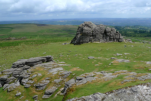
Tors
Tors are a freestanding rocky outcrop that rises up out of the, often gentle sloping, surrounding landscape. Dartmoor is often used as a case study for students:
- The granite tors seen on Dartmoor originated as a granite batholith.
- Over time the material above the batholith was weathered and removed by rivers and glaciers. As this process continued over millions of years, the overlying material was totally removed, leaving behind the tors and valleys seen on Dartmoor.
I have been searching the internet for a user friendly diagram of the formation of a tor but I haven’t found anything that I felt would be suitable to children and or relatively easy to understand. I will keep looking and if I find anything I will post on it here. Otherwise we may have to ask our students to draw their own diagrams. Which isn’t necessarily a bad thing but I think it’s always useful to have a diagram ready to show students.
Bogs and marshes
- Due to the impermeable nature of granite, landscapes are often marshy as water cannot soak in to the soil.
V shaped river valleys
- V-shaped river valleys formed by the numerous surface streams. Valley sides are steep due to the resistant nature of the granite.
Rugged uplands
- Poor soils and soil drainage means that the land is unsuitable for growing crops. Granite landscapes are mainly used for grazing sheep.
The British Geological Survey has a ‘make a map’ facility on their website where you are able to create a geological map, which you can print, of Britain based on the rock type you are looking at a particular time. Place names can be omitted from the map as well so it could be a good activity to get students to compare their geological map with a map of the UK and ty to work out where particular geological landscapes occur. So as well as learning about geological landscapes, students are also practicing their map skills.
http://www.bgs.ac.uk/discoveringGeology/geologyOfBritain/makeamap/map.html
If the different geological landscapes were briefly introduced in the same lesson, using Google Earth to set up a tour around the different sites in the UK. Students could try to work out the geology of the rocks from the landscape above and perhaps other photographs.
AQA has again some good activities and games that students can use to help them learn about different characteristics and landscapes. As part of the GCSE students need to also learn about uses of landscapes and human impacts. In starting to develop student’s enquiry skills a good activity may be to give students some characteristics of the landscape e.g. poor soil quality and get them to think what use the land could be used for?
The Dartmoor National Park have a short video on YouTube to give students a feel for what Dartmoor is like and the types of activity that take place on the moor. Useful for students who haven’t visited the area and EAL students.
